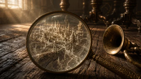
In the quiet, residential outskirts of New Haven, there is an ordinary, two-story colonial home that looks exactly like every other house on the block. It features a manicured lawn, a fresh coat of eggshell paint, and a wrap-around porch. However, the house possesses an impossible secret hidden just beneath its architecture. For those who know how to listen to the shifting of the timber, the building does not contain simple crawlspaces or insulation. It houses a vast, shifting geographical expanse known to a select few as the Floorboard Cartography, a network of microscopic, invisible cities existing entirely within the grain of the wooden floorboards.
The Geography of the Timber
Within the bounds of magical realism, space is never a fixed mathematical certainty. It is elastic, capable of folding in on itself to accommodate the forgotten or the discarded. The house was built in the late nineteenth century using reclaimed lumber from an ancient, uncharted forest. Over decades of settlement, the knots, rings, and grain lines of the oak floors began to warp, expanding inwardly to form a microscopic topographic landscape.
To an ordinary resident walking across the living room, a creaking plank is just a minor domestic annoyance. But to a Floorboard Cartographer, that specific groan is the tectonic shift of a vast canyon system. A dark knot in the wood grain is not a natural flaw in the timber; it is a sprawling, soot-choked industrial metropolis populated by minuscule silhouettes who build their homes out of falling dust motes and lint fibers. The concentric growth rings of the wood serve as the city walls, defining territorial boundaries that have existed for centuries right beneath our feet.
The Tools of the Domestic Explorer
Mapping an invisible world that changes every time the house settles requires specialized, highly unconventional tools. The cartographers who study the house do not use satellites or compasses; they rely on domestic archaeology and acute sensory translation.
The Acoustic Ear-Horn: Cartographers utilize vintage brass listening tubes pressed directly against the seams of the wood. By isolating the sounds of the house, they can distinguish between the natural expansion of the building and the distant, rhythmic chiming of microscopic clock towers or the low murmur of tiny marketplaces echoing from the hallway closet.
The Dust-Ink Quill: Maps of the floorboard cities are drawn on thin parchment paper using a specialized ink formulated from vinegar, graphite powder, and the exact dust swept from the room being mapped. The ink acts as a physical anchor. If a map is drawn using external materials, the changing humidity of the room will cause the ink lines to drift, invalidating weeks of surveying.
The Risk of the Great Settlement
The most volatile aspect of the Floorboard Cartography is the constant, unpredictable threat of architectural shifting. A house is a living entity that expands in the summer humidity and contracts during the dry winter cold. For the miniature civilizations living inside the wood, these seasonal transitions are cataclysmic, world-altering geological events.
When the foundation of the house settles by a fraction of an inch, an entire mountain range in the dining room might collapse, erasing a dozen city-states overnight. The true danger for a human cartographer is the phenomenon known as the Rift. If an explorer spends too much time staring through a magnifying glass at a specific crack in the wood, their consciousness can become trapped within the perspective of the miniature city. They do not physically shrink; instead, their mind gets lost in the infinite, non-linear geography of the grain. They become unable to perceive the macro-world around them, spending the rest of their days wandering an invisible labyrinth of dust and timber, permanently separated from the family living just one floor above.